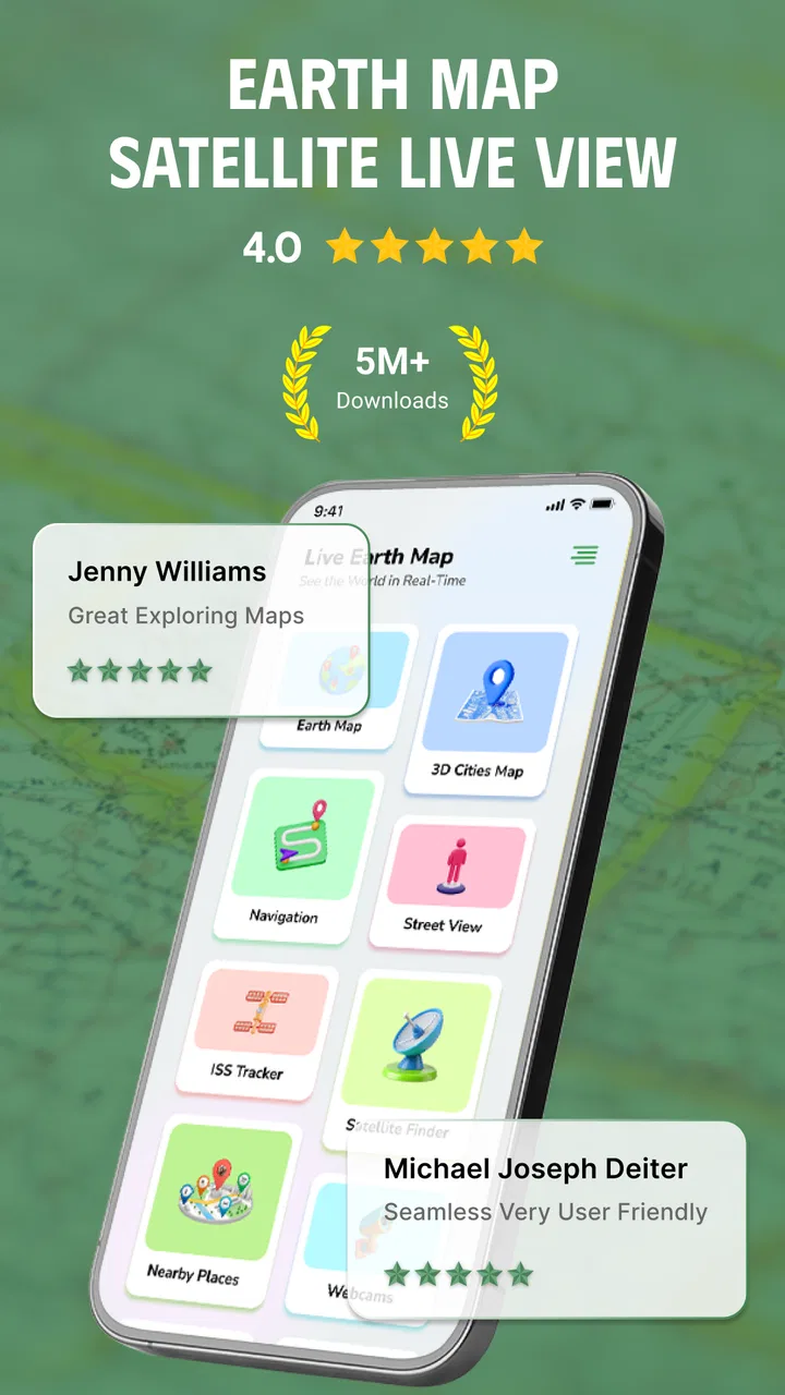
Earth Map Satellite Live View
- 3.7
- Rating
- 5.00M
- Installs
- Free
- Price
 Analysis by App-foxy
I spent my time with Earth Map Satellite Live View looking at one central idea: turning a phone into a visual window over the planet while keeping location and navigation close at hand. That sounds simple, but the experience is more useful in some situations than in others. The satellite perspective can make places feel understandable in a way that a standard road map often does not, especially when I want to recognize terrain, coastlines, open spaces, or the shape of a destination before going there.
This is a free Maps & Navigation app from Synlox Studio, aimed at everyone rather than a specialist audience. It has passed the five-million-install mark and holds an average rating of 3.7 from around 5.7 thousand ratings, so it is clearly familiar to a substantial number of Android users. I would describe it as a visual exploration and navigation companion, not a complete replacement for the map app already built into your phone.
Satellite imagery is the reason to open it
The most interesting capability here is the satellite live view. Instead of relying only on colored roads, labels, and flat map shapes, I can examine the physical appearance of an area from above. That changes the way I approach a location. A park is no longer just a green shape, a coastline becomes a recognizable boundary, and a large property can be understood by its surrounding fields, buildings, and access roads.
You May Also Like

 Blood Strike: 2.5 Anniversary
Blood Strike’s Loadouts Turn Every Drop Into a Tactical Gamble
A close look at Blood Strike’s custom loadouts: how fast access to signature weapons reshapes its battle royale rhythm, rewards preparation, and narrows the gap between fights.

 Pandora - Music & Podcasts
Pandora’s Music Is Easy to Start, but Harder to Recover
Pandora’s strength is its low-effort path from a seed to a station. Its weak spot is how much confidence it asks you to place in connection, setup, and quiet recovery.

 8 Ball Pool
 Is Built on Rivalries, Rematches, and Routine
A close look at the rivalries, rematches, shared routines, and unanswered safety questions that turn a quick pool match into a persistent mobile community.

 Samsung Music
’s Quiet Strength Is Playing What You Already Own
Its reach comes less from spectacle than from dependable access to a personal library. That simplicity is both the app’s strongest retention engine and its ceiling.

 AccuWeather: Weather Radar
AccuWeather Review: A Quick, Clear Forecast for Everyday Decisions
For everyday plans, the best forecast is the one you can understand quickly. AccuWeather makes rain timing, radar, and local conditions easy to act on, with a few trade-offs.

 Hill Climb Racing
Why Hill Climb Racing Still Turns Crashes Into One More Run
A tiny car, a bumpy hill and one more upgrade: Hill Climb Racing keeps resurfacing because its simple chaos makes every near-miss feel personal.
More From Our News Desk



That visual context matters when a conventional map leaves me asking, “What will this place actually look like?” A road map is usually better for turn-by-turn decisions, but satellite imagery is better for orientation. I can compare the map with the landscape I expect to see, identify broad landmarks, and understand whether a destination is surrounded by dense development, open land, water, or uneven terrain.
The app’s appeal is therefore less about replacing every navigation tool and more about adding a different layer of understanding. The satellite view is most valuable before the journey, when visual preparation can prevent confusion later. I find it particularly helpful when the written address is technically correct but does not explain the setting around it.
What the aerial perspective changes
When I use ordinary navigation, I tend to follow the highlighted route and wait for instructions. With an aerial view, I naturally slow down and inspect the destination itself. I look for the relationship between the main road and the building, the direction of nearby paths, and the amount of open space around the point I selected. This does not guarantee that every visible feature is current, but it gives me a more physical sense of the area than a list of street names can provide.
It is also useful for virtual travel. I can move from a familiar neighborhood to a distant coastline or a major landmark and compare the shape of places from above. That makes the app enjoyable even when I am not actively planning a trip. The experience feels more exploratory than a typical navigation session, because the map becomes something to inspect rather than merely follow.
Still, I would not confuse a satellite image with a live camera feed. The wording around live view may suggest immediacy, but what I am really getting is a satellite-style visual map experience, not a continuously changing view of the ground. For planning, that distinction is important. I use the imagery to understand layout and surroundings, while treating current road conditions, temporary closures, construction, and changing access as matters that require a more current source.
How I use it in practice
My most comfortable workflow begins with exploration rather than navigation. I open the map, locate the area I care about, and inspect it from above before deciding which details deserve a closer look. I then switch mentally between the visual landscape and the route problem: where is the destination, what surrounds it, and which nearby road or landmark will help me recognize it?
This approach is more effective than immediately searching for the fastest route. If I am meeting someone at a large venue, for example, the address may lead to the correct property but still leave several possible entrances. Satellite imagery can help me understand the building’s position relative to the road and nearby open areas. I can then use a conventional navigation service for the final driving instructions, where traffic data and spoken guidance are usually more important.
A second useful habit is to inspect the destination at more than one zoom level. At a wider view, I can see the neighborhood or landscape around it. At a closer view, I can study the immediate surroundings. Looking only at the closest level can make a place seem disconnected from its context, while staying too far out makes it difficult to identify practical landmarks. This two-stage check is a small adjustment, but it makes the satellite feature much more useful.
A realistic everyday example
Imagine that I am visiting a large public area for the first time. The address points to a broad location, but I do not know whether the entrance is beside a busy road, behind a parking area, or near a visible landmark. Before leaving, I use the aerial view to understand the shape of the site and the roads around it. I note a distinctive building or open area that should be easy to recognize, then use my usual navigation app during the drive.
Once I arrive, that preparation can reduce the moment of uncertainty when the phone says I have reached the destination but I still cannot see the correct entrance. The satellite view has not replaced navigation; it has filled in the visual information navigation often leaves out. That is the clearest practical benefit I found.
The same method works for checking a walking destination, a campsite area, a waterfront, or a rural address. In each case, the important question is not simply “How do I get there?” but “What will the surrounding area look like when I arrive?” Earth Map Satellite Live View is strongest when that second question matters.
Navigation is helpful, but I would keep a second tool ready
The app combines the satellite experience with accurate GPS navigation as part of its purpose, and that makes it more convenient than a purely visual globe. I can use my position as a reference instead of exploring blindly. That is useful when I am checking how far I am from a destination or trying to relate an unfamiliar place to where I currently stand.
However, I would still keep a dedicated navigation alternative available for journeys where live traffic, lane guidance, transit information, offline access, or highly detailed route instructions are essential. The usual phone map is generally the safer primary tool for a complicated drive. Earth Map Satellite Live View works better as the visual companion that helps me understand the destination before and during the trip.
This division of labor also makes the app easier to judge. If I expect one application to handle every navigation need, I may find it limited. If I want a satellite-centered way to inspect places and supplement GPS guidance, its role becomes much clearer.
Where the experience has friction
The first trade-off is that visual detail can be attractive without being operationally precise. A satellite image may show a road, path, field, or building, but that does not automatically tell me whether I am allowed to use it, whether it is open today, or whether the image reflects the current condition. I treat what I see as geographic context, not as permission or a guarantee of access.
That matters especially in rural and outdoor settings. A visible track may look like a convenient shortcut, yet it could be private, unsuitable for a vehicle, blocked, or difficult to use. The app can help me understand the terrain and surrounding layout, but I still need common sense and local signs. This is one of the most important limits of satellite-based planning.
Another trade-off is focus. A standard navigation app is designed to answer an immediate question quickly: which turn comes next? The satellite view encourages inspection, and that can be a distraction if I am already moving. I would plan with it before leaving and avoid studying the screen while driving. For safe use, the visual exploration belongs at home, during a stop, or with another person handling the phone.
The free entry point is welcome, but the app also offers in-app purchases ranging from $4.49 to $14.99 per item. That means I would pay attention to what is included in the basic experience before deciding whether an upgrade is worthwhile. I would not purchase simply because the aerial imagery looks interesting; I would first confirm that the extra value matches my actual routine, such as frequent trip planning or repeated use of location tools.
The current version is 1.1.0.58, and the app requires Android 10 or later. For someone using an older phone, that requirement is an immediate practical consideration. On a supported device, I would also expect the smoothness of map movement to depend on the phone, the connection, and the amount of imagery being displayed. Satellite-style visuals can be more demanding than a simple road map, so I prefer using them when I have a stable connection and enough battery for a longer planning session.
Why it does not replace every alternative
Compared with a familiar road-navigation app, this one gives more emphasis to the physical appearance of places and less emphasis to the complete driving ecosystem. A dedicated navigation service is usually the better choice when I need traffic-aware routing, frequent spoken instructions, public transport planning, or a large database of businesses and services.
Compared with a globe or travel-exploration app, Earth Map Satellite Live View feels more practical because GPS navigation is part of the experience. I am not only looking at distant places; I can connect the visual view with a real destination and a route. The compromise is that it may not offer the same depth of editorial travel information or the same richness of place discovery that a specialized travel platform provides.
That makes the app a particularly good secondary tool. I use a normal map for the journey itself, a travel app for recommendations and local information, and this satellite-focused app when I need to see the physical arrangement of a place. Trying to force one app to perform all three jobs would make the comparison unfair and probably lead to disappointment.
Who gets the most value from it
I think the best audience is people who understand places visually. If you often look at a destination before visiting, plan trips around landmarks, check the layout of large properties, or enjoy exploring distant areas from above, the app has a clear purpose. It is also a sensible choice for travelers who want an extra layer of orientation rather than another list of directions.
It can help families preparing for a day out, visitors meeting at a confusing venue, photographers scouting a general area, and curious users who enjoy virtual travel. In each case, the benefit comes from reducing the gap between a pin on a map and the real landscape around that pin.
I would be more cautious about recommending it to someone who wants a single, fully featured replacement for their established navigation service. If your priority is the fastest route, current traffic, spoken driving instructions, transit details, or dependable offline planning, another map application may be a better primary choice. Likewise, if you rarely inspect destinations visually, the satellite layer may not justify adding another navigation app to your phone.
The age rating is Everyone, which fits the straightforward exploration concept. I also like that the app is free to try, because the usefulness of satellite viewing is personal: some people immediately understand its value, while others prefer the clarity of a simple road map. The purchase range makes it sensible to test the workflow first instead of assuming that paid features will automatically improve everyday navigation.
Small habits that make it more useful
I would save the app for three specific moments: checking a destination before departure, orienting myself around a large or unfamiliar site, and exploring places where the physical landscape is more informative than street labels. Defining those moments prevents it from becoming a less convenient copy of the default map application.
I would also compare what I see with signs, official access information, and the route shown by my primary navigation tool. This is not unnecessary caution; it is the right way to use aerial imagery. The strongest workflow combines visual preparation with current practical information instead of trusting one layer alone.
Finally, I would use the satellite perspective to form a mental picture, then put the phone away when I no longer need it. Remembering the broad shape of the destination, a nearby landmark, and the direction of the main approach is often more useful than staring at the screen continuously. That is where the app can quietly improve a trip without becoming the trip itself.
After testing it as a Maps & Navigation app, my opinion is positive but specific. Earth Map Satellite Live View is worth trying if satellite-based orientation is the feature you have been missing. It gives me a more physical understanding of destinations and makes virtual exploration feel connected to real-world movement. Its 3.7 average rating suggests a mixed but meaningful reception, and I can understand why: the concept is useful, but its value depends heavily on whether I need visual context rather than just directions.
I would recommend it to a friend as a companion for planning and exploring, not as an automatic replacement for every map service. Synlox Studio has created an app with a clear identity, and the free price makes that identity easy to test. If you regularly wonder what a place looks like beyond the pin, this is where it earns a place on your phone. If all you want is the quickest route from one address to another, your usual navigation app will probably remain the better choice.
FAQs for Earth Map Satellite Live View
01What is Earth Map Satellite Live View?
Earth Map Satellite Live View is a map and satellite-imagery application designed to let you explore locations around the world from your phone. It provides a visual, map-based experience for viewing terrain, cities, coastlines, and other geographic areas. It is best understood as an exploration and reference tool rather than a guaranteed real-time window into current events or continuously updated satellite footage.
02Does Earth Map Satellite Live View show live satellite images?
Despite the word “Live” in its name, satellite imagery in apps of this type is generally not a live video feed. Images may come from previously captured satellite or mapping data and can vary in age, resolution, and coverage depending on the selected location. Users should not expect to monitor traffic, weather, private property activity, or changing events in real time. Always check the app’s imagery date or source information when available.
03Does the app require an internet connection?
An internet connection is normally required to load map tiles, satellite imagery, search results, and location information. Performance can depend heavily on connection speed and signal strength, especially when zooming into detailed areas. Some previously loaded map content may remain temporarily available through caching, but this should not be treated as full offline support unless the application clearly provides a download or offline-map feature.
04Is Earth Map Satellite Live View free to download and use?
The application may be available as a free download, but users should review its store listing carefully for advertising, optional purchases, subscriptions, or limitations on certain features. Free access can sometimes include fewer viewing options or more frequent advertisements. Before confirming any payment, check the subscription price, billing period, trial terms, and cancellation instructions shown on your Android or iOS device.
05Does Earth Map Satellite Live View use my location or collect personal data?
The app may request location access to center the map on your current position or provide location-based features, although basic map browsing may work without granting precise location permission. Review the permissions requested during installation and allow only those you consider necessary. It is also advisable to read the app’s privacy policy to understand how location data, device information, analytics, and advertising identifiers may be handled.
Pros
- Live satellite imagery helps explore places from a different perspective.
- Simple map controls make zooming and panning easy for most users.
- Useful for checking terrain
- coastlines
- cities
- and remote locations.
- Location search speeds up finding specific countries
- cities
- and landmarks.
- Can support trip planning and general geographic research.
Cons
- Satellite images may be outdated in some regions.
- Image quality and detail vary significantly by location.
- Some features may require a subscription or contain advertisements.
- The app can use considerable mobile data when browsing imagery.
- Offline viewing may be limited or unavailable for many map areas.

Earth Map Satellite Live View
Gallery